


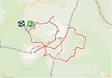
J6 Tour des Sucs de Haute Ardèche

CABERMAT
User

Length
13.4 km

Max alt
1585 m

Uphill gradient
401 m
Km-Effort
18.8 km

Min alt
1348 m

Downhill gradient
403 m
Boucle
Yes
Creation date :
2025-05-23 07:59:13.81
Updated on :
2025-05-28 14:12:21.808
6h02
Difficulty : Difficult

FREE GPS app for hiking
 SityTrail
IGN / Geographical institutes
SityTrail Plus
The world is yours!
About
Trail Walking of 13.4 km to be discovered at Auvergne-Rhône-Alpes, Ardèche, Le Béage. This trail is proposed by CABERMAT.
Description
Attention qques portions sont hors chemin et des marécage à éviter.
Positioning
Country:
France
Region :
Auvergne-Rhône-Alpes
Department/Province :
Ardèche
Municipality :
Le Béage
Location:
Unknown
Start:(Dec)
Start:(UTM)
591409 ; 4967332 (31T) N.
Comments